 |
| Shigri Peak- Naran |

Thursday, July 9, 2015

Wednesday, April 1, 2015
CATHEDRAL PEAK (Hunza- Pakistan)

Cathedral Peak is located near Passu village, upper Hunza, in Gilgit Baltistan region of Pakistan.

Cathedral Peak is called "Tupopdan" in local language which means "mouthful of sun mountain ". It is also know as Passu Cones.
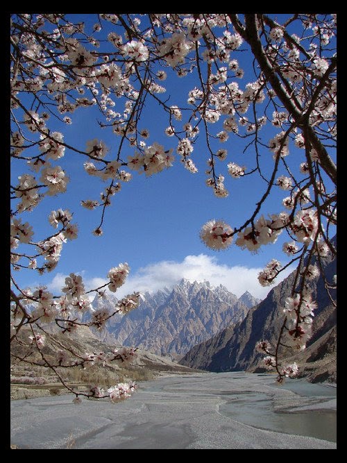
Cathedral Peak is located near Hunza River

Cathedral Peak was climbed in 1987, by British P.Cox, L.Griffin et M.Woolridge.

Monday, March 23, 2015
SHISPARE PEAK - PAKISTAN

Elevation: 24,970' (7,611 m)
Prominence: 4,072' (1,241 m)
Location Gilgit-Baltistan, Pakistan
Mountain Range: Karakoram
First ascent: July 21, 1974
First ascenders: Leszek Cichy, Herbert Oberhofer, M. Grochowski, J. Poreba, A. Mlynarczyk, J. Holnicki-Szulc, Hubert Bleicher

Shispare peak is also called "Shispare Sar" and "Shisparé Sar".

Shispare Peak is located in Karakoram mountain range of Pakistan in Passu Glacier.This glacier is linked with Batura Glacier. Shispare Peak lies at the east of the Batura Wall, which is the highest part of the Batura glacier.

Shispare Peak is at the elevation of 24,970' (7,611 m). Prominence: 4,072' (1,241 m).

Shispare Peak is ranks as the 14th highest mountain in Gilgit-Baltistan and the 19th highest mountain in Pakistan. The nearest peaks located to this peak are Bojohaghur Duanasir, Shanoz, Atabad, Batura Sar, Shunuk, and Shaujerab.

Shispare Peak is one of the high peaks of the Batura Muztagh Mountains, which is the westernmost sub range of the Karakoram mountain range in the Hunza-Nagar district of Gilgit-Baltistan province in Pakistan. This peak is near the end of the Batura Muztagh mountains. Batura Sar is the parent peak.

The Hunza River curves around the south west, and northwest sides of the Batura Muztagh, and Shispare towers above the western bank of the river.In turn, the Hunza Valley lies in the Gilgit District of Gilgit-Baltistan, Pakistan.


Shispare peak commands large drops in three directions (north, east, and south). Shispare has a strikingly large and steep north east.It is copy of K2 and one of the most beautiful peak in the region.

Shispare was the first major peak in the range to be successfully climbed, in 1974, by the "Polish-German Academic Expedition" under the leadership of Janusz Kurczab. Bleicher, L. Cichy, M. Grochowski, J. Holnicki-Szulc, A. Mlynarczyk, H. Oberhofer, J. Poreba.The first ascent route followed the Pasu Glacier to the East Ridge, between the Pasu and Ghulkin Glacier.

Best time to climb Shispare Peak is from June to August.

Monday, March 16, 2015
List of 0000-1000 Meters Peaks in Pakistan
LIST OF 000-1000 METERS PEAKS IN PAKISTAN
Name : Koh-i-Daram
Height in Meters : 965 m
Mountain Range : Makran range, Gawadar Baluchistan
Name : Tazghi
Height in Meters : 955 m
Mountain Range : Chagai Hills Baluchistan
Name : Koh-i-Taftan
Height in Meters : 797 m
Mountain Range : Ras Koh, Baluchistan
Tuesday, March 3, 2015
Khunyang Chhish Mountain (Gilgit–Baltistan, Pakistan)
Khunyang Chhish located in Karakoram mountains Range of Pakistan. It is the second-highest mountain in the Hispar Muztagh, a subrange of the Karakoram mountains.

Khunyang Chhish mountain is at the Elevation 7,852 m (25,761 ft. It has a Prominence of 1,765 m (5,791 ft). It is ranked 21st in the world and 8th in Pakistan.

Khunyang Chhish mountain is also called Kunyang Kish and Khiangyang Kish, among others.
Khunyang Chhish lies in Skardu District of Baltistan. It is located in the heart of the Hispar Muztagh, north of the Hispar Glacier, one of the major glaciers of the Karakoram. It rises on the southwest side of the Khunyang Glacier
Khunyang Chhish is notable for its rise above local terrain. It is a steep, pointed, and complex peak. It rises almost 4,000 metres (2.5 mi) above its southern base camp on the Khunyang Glacier, and it rises 5,500 metres (3.4 mi) above the Hunza valley in about 33 kilometres (21 mi).
Not counting the two Pumari Chhish summits 4 km to the ENE, the Kunyang Chhish massive has five peaks:
- Kunyang Chhish Main, 7852 m
- Kunyang Chhish South, 7620 m, 700 m SSW, with a prominence of only about 100 m/
- Kunyang Chhish East 7400 m, 2 km ESE, 240 m prominence.
- Kunyang Chhish West, 7350 m, 1.5 km W, 170 m prominence. Also known as Pyramid Peak.
- Kunyang Chhish North, 7108 m, 6 km NNE, 517 m prominence.
The first ascent was accomplished by a Polish team led by Andrzej Zawada in 1971. They climbed a long route up the South Ridge of the peak from the Pumari Chhish Glacier.
***************************************************
Sunday, February 8, 2015
Kala Chitta Mountain Range

Kala Chitta Mountain Range is a mountain range located in the Attock District of Punjab, Pakistan.

The Kala Chitta Range rises to an average height of 450-900 metres (3,000 ft) above sea level and extends for about 72 kilometres (45 mi) in the provinces of Punjab and Khyber Pakhtunkhwa The Kāla Chitta Range thrusts eastward across the plateau toward Rawalpindi; the valleys of the Haro and Soan rivers cross the plateau from the eastern foothills to the Indus river.


Kala Chitta Mountain is also known as Kala Chita Ghar, Kala Chitta Dhar, Kala-Chitta Range, Kāla Chita Ghār, Kāla Chitta Dhār, Kālā-Chitta Range.

Friday, January 16, 2015
MITRE PEAK (Karakorum Range -Pakistan)

MITRE PEAK is a mountain in the Karakoram mountain Range near Concordia in Pakistan.Concordia is the confluence of the Baltoro and Godwin-Austen Glaciers. It is a 6,010 m (19,720 ft) high mountain in the central Karakoram.


Mitre peak is is located on the confluence of the branches of the Baltoro Glacier with the Gasherbrum branch arriving from the SE and the Godwin Austin branch arriving from the NE.


Mitre Peak is a majestetic peak, It is famous only for its shape and location. Viewed from the Concordia Glacier, it does not appear to be very high, and cannot be seen from a distance. It is relatively at low altitude by the neighbors high mountains, but it makes an impression equal to its more lofty neighbours.There are over 60 peaks close by which are so higher. Some of the most famous peaks are: K2 (8611m), Gasherbrum I (8068m), Broad Peak (8047m), Gasherbrum II (8035m) and the little lower, very impressive Gasherbrum IV (7925m). It sits across from Broad Peak, the 12th highest mountain on Earth.

Mitre Peak can be seen from Concordia

Best time to climb to Mitre Peak is from June to August .

Subscribe to:
Posts (Atom)